UK Hydrographic Office Launches Digital Format for ADMIRALTY Sailing Directions
Why It Matters
By digitizing essential navigational guidance, ADSD accelerates decision‑making on the bridge and reduces planning time, enhancing safety and efficiency on the world’s busiest shipping lanes. The move also signals a broader digital transformation across the maritime sector, positioning UKHO as a leader in modern navigation services.
Key Takeaways
- •ADSD launches with 38 popular Sailing Directions volumes.
- •Geo‑display improves situational awareness for mariners.
- •88% find ADSD intuitive; 91% say geo‑display aids understanding.
- •Search, bookmarking, and route indicators speed passage planning.
- •Full global coverage expected by end of 2026.
Pulse Analysis
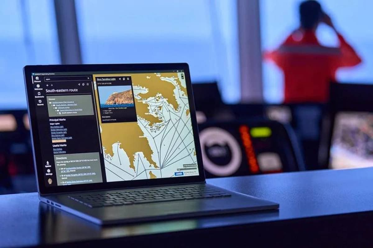
The maritime industry has long relied on paper‑based Sailing Directions to navigate complex coastlines and congested ports. As vessels adopt integrated bridge systems and real‑time data feeds, static documents increasingly hinder efficient route planning. The UK Hydrographic Office’s launch of ADMIRALTY Digital Sailing Directions (ADSD) addresses this gap by delivering the same authoritative content in a fully searchable, geo‑referenced format. By embedding high‑resolution coastal imagery and interactive routing cues, ADSD aligns with the digital‑first expectations of modern ship operators and supports the broader push toward electronic navigation.
ADSD’s user‑centric design stems from extensive trials with more than 50 navigating officers across diverse vessel classes. The platform’s integrated geo‑display lets captains visualize hazards and landmarks directly on a map, while powerful search and bookmarking tools cut the time needed to locate port specifics, traffic patterns, and navigational warnings. Survey results show 88 % of participants found the interface intuitive, 91 % credited the geo‑display with clearer understanding, and another 88 % reported measurable time savings during passage planning. These metrics underscore the tangible efficiency gains that digital navigation aids can deliver.
Beyond immediate operational benefits, ADSD signals a strategic shift in how hydrographic data is packaged and sold. The initial release of 38 volumes covers the busiest corridors linking Northern Europe to East Asia, capturing 27 of the world’s top 30 ports. Full global coverage is slated for the end of 2026, positioning UKHO to become the default digital source for worldwide routing information. Competitors and ancillary service providers are likely to follow suit, accelerating the maritime sector’s transition to cloud‑based, interoperable navigation ecosystems that promise safer, greener, and more cost‑effective voyages.
UK Hydrographic Office Launches Digital Format for ADMIRALTY Sailing Directions
Comments
Want to join the conversation?
Loading comments...