Satellite Spies Northern Lights over Iceland and Canada | Space Photo of the Day for Feb. 23, 2026
•February 23, 2026
0
Why It Matters
Even a G1 storm can affect satellite communications and power grids at high latitudes, highlighting the need for continuous monitoring. The imagery demonstrates the role of Earth‑observation satellites in real‑time space weather assessment.
Key Takeaways
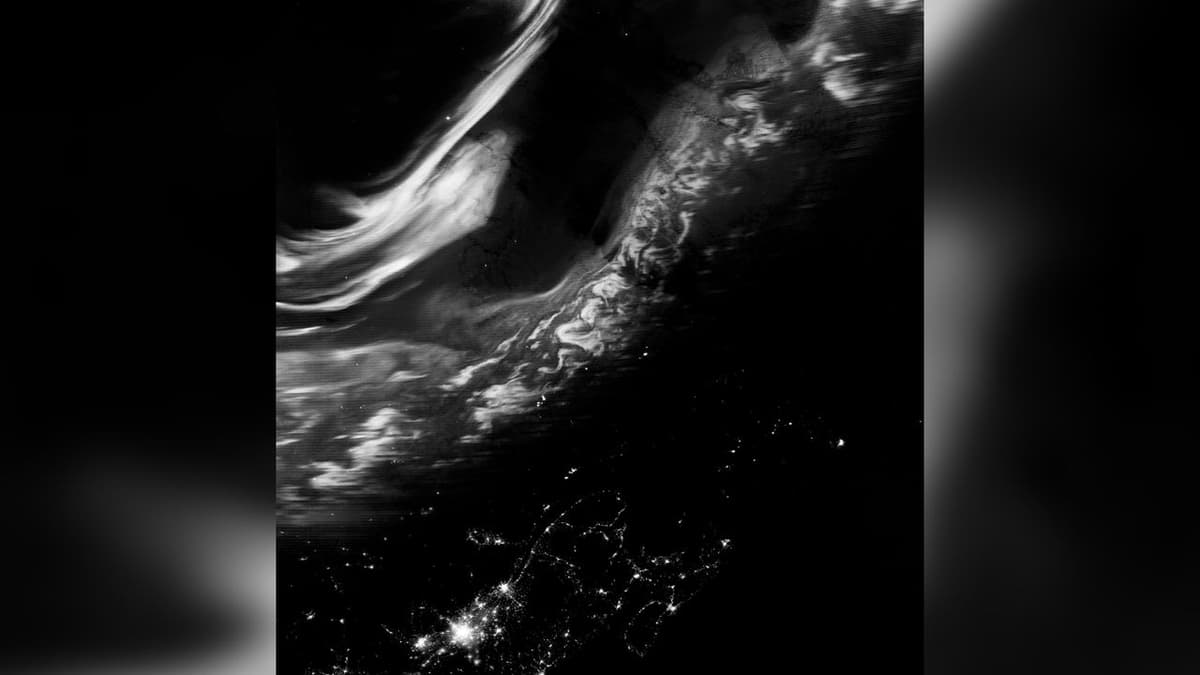
- •VIIRS on Suomi NPP captured auroras over Iceland, Canada.
- •Storm rated G1, minor but visible at high latitudes.
- •Auroras result from solar particles colliding with atmospheric gases.
- •Images show green, red, blue/purple emissions at varying altitudes.
- •Satellite data aids space weather monitoring and forecasting.
Pulse Analysis
The aurora borealis is a direct visual manifestation of space weather, occurring when charged particles from the Sun interact with Earth’s magnetosphere. During a G1‑level geomagnetic storm, the influx of solar wind is modest, yet it can still energize electrons that travel along magnetic field lines toward the polar regions. Collisions with oxygen and nitrogen at altitudes ranging from 100 to 400 km release photons that appear as green, red, or even blue‑purple curtains. Although classified as minor, such storms can subtly perturb satellite orbits and high‑frequency radio propagation, making them worth tracking.
The Visible Infrared Imaging Radiometer Suite (VIIRS) aboard the Suomi National Polar‑Orbiting Partnership (Suomi NPP) provides a unique bird’s‑eye view of these events. Its day‑night band captures low‑light emissions, rendering auroral structures in high contrast even when ground observers report only faint glows. By delivering near‑real‑time, global coverage, VIIRS complements ground‑based magnetometers and all‑sky cameras, feeding data into space‑weather models used by NOAA and the aerospace industry. The February 16 images illustrate how a single satellite pass can document the full geographic extent of an auroral oval. For commercial operators, timely aurora detection translates into actionable intelligence.
Power‑grid managers can anticipate geomagnetically induced currents, while airlines adjust polar routes to avoid communication blackouts. The tourism sector, especially in Iceland and Canada, leverages forecasted displays to attract astrotourists, boosting local economies. As solar activity ramps toward the next maximum, integrating satellite observations like VIIRS with machine‑learning forecasts will improve prediction accuracy. Continued investment in polar‑orbiting platforms ensures that both scientific research and industry stakeholders stay ahead of space‑weather risks.
Satellite spies northern lights over Iceland and Canada | Space photo of the day for Feb. 23, 2026
0
Comments
Want to join the conversation?
Loading comments...