Waymo and Waze Launch Pothole Detection Pilot, Logging 500 Road Defects
Companies Mentioned
Why It Matters
The Waymo‑Waze initiative illustrates how autonomous‑vehicle data can be repurposed for public‑service applications, blurring the line between private tech assets and municipal infrastructure. By providing cities with a continuous, sensor‑driven feed of road conditions, the program could accelerate repair cycles, lower vehicle damage costs, and improve safety for all road users. Moreover, the model demonstrates a scalable pathway for other autonomous fleets to monetize sensor data beyond their core transportation services. If successful, the collaboration could pressure other navigation and ride‑hailing platforms to adopt similar data‑sharing arrangements, reshaping how urban road‑maintenance budgets are allocated and how cities prioritize infrastructure projects in an era of increasingly connected mobility.
Key Takeaways
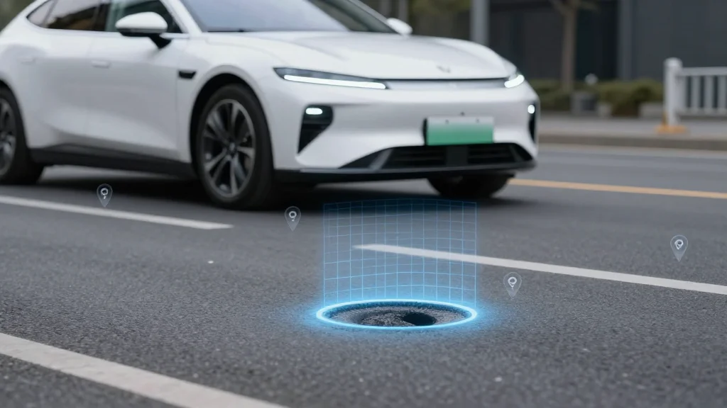
- •Waymo and Waze have logged ~500 potholes across five pilot cities.
- •The program uses Waymo’s cameras, lidar and feedback sensors to detect road damage.
- •Waze users can verify reports, creating a human‑in‑the‑loop validation layer.
- •Houston will join the pilot “in the near future,” expanding the geographic scope.
- •Cities receive free, real‑time pothole data via the Waze for Cities platform.
Pulse Analysis
Waymo’s decision to open its sensor data to a third‑party navigation app marks a strategic shift from a purely proprietary model to a data‑as‑a‑service approach. Historically, autonomous firms have guarded raw sensor feeds to protect competitive advantage, but the pothole pilot shows that sharing curated insights can generate public‑good outcomes while reinforcing brand trust. The collaboration also positions Waymo as a de‑facto standards‑setter for infrastructure‑focused AI, a niche that could become a revenue stream as municipalities seek smarter maintenance solutions.
From a market perspective, the partnership gives Waze a differentiated safety feature that could boost user engagement against rivals like Google Maps and Apple Maps. The human verification step leverages Waze’s existing community, turning a passive navigation tool into an active crowdsourcing platform. This synergy may encourage other map providers to seek similar data pipelines, potentially igniting a wave of sensor‑data licensing deals across the autonomous sector.
Looking ahead, the pilot’s success will hinge on data accuracy, city integration capabilities, and the willingness of municipal budgets to act on the insights. If the pilot demonstrates measurable reductions in repair times and vehicle damage costs, it could unlock public funding for broader deployments, cementing a feedback loop where autonomous fleets continuously improve road conditions, which in turn enhances fleet performance. The long‑term implication is a more resilient, data‑rich urban mobility ecosystem where private autonomy and public infrastructure co‑evolve.
Waymo and Waze launch pothole detection pilot, logging 500 road defects
Comments
Want to join the conversation?
Loading comments...