Autodesk Strengthens Bridge Between Revit and Forma
Autodesk has launched a tech preview that positions Revit as the first Forma Connected Client, linking the desktop BIM tool directly to Autodesk’s AECO cloud platform. The integration enables teams to import site, terrain and parcel data from Forma Site Design and Building Design into Revit without manual file transfers. Contextual data from the Forma Data Marketplace and environmental analysis capabilities are now accessible within Revit, while the new AI‑powered Autodesk Assistant offers task automation. All Revit subscribers receive complimentary access to the broader Forma suite, extending collaborative and AI‑driven workflows.

Trimble to Acquire Construction AI Risk Management Specialist
Trimble announced it will acquire Document Crunch, a construction‑focused AI risk‑management software provider, though financial terms remain undisclosed. Document Crunch’s platform scans contracts, invoices and specifications to flag payment disputes, compliance gaps and notification failures, and is already deployed on...

Embodied Carbon Calcs for BIM Objects
NBS, part of Hubexo, has teamed with Circular Ecology to publish a practical guide that embeds embodied carbon data into BIM objects. The guide tackles fragmented carbon information by applying BS EN 15804 A1‑A5 metrics at the object level using a...

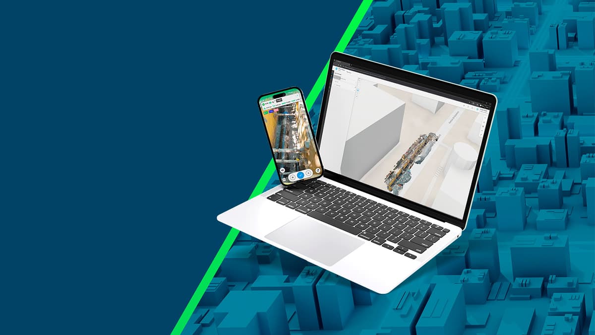
DroneDeploy Partners with Cairn Homes
Irish homebuilder Cairn Homes has entered a multi‑year enterprise agreement with DroneDeploy, deploying the firm’s aerial and ground reality‑capture platform across more than 25 residential projects. The partnership standardises the use of drones, 360‑degree cameras and handheld 3D scanners, delivering...

Snaptrude AI: Conceptual Design and Beyond
Snaptrude, a browser‑based BIM challenger, is concentrating its AI development on the conceptual and schematic design stages, where architects spend most time. Its proprietary Universal Graph Representation provides a project‑wide, relationship‑based model that lets modular AI agents handle high‑friction tasks...

Building Data Foundations for the Future
HSO’s aec360 platform combines Microsoft Dynamics 365 with AEC‑specific tools to deliver AI‑driven automation for architecture, engineering and construction firms. A highlighted feature is an AI‑enabled RFP agent that evaluates proposals, scores success probability and generates Go/No‑Go decisions with project...

Design-to-Build in the Age of AI
Allplan, led by Sunil Pandita, is transforming from a structural‑engineering‑focused authoring tool into a full design‑to‑build platform that leverages openBIM, AI‑driven automation, and hybrid cloud‑desktop workflows. The company emphasizes data sovereignty under EU regulations while expanding downstream into detailing, fabrication,...

Track3D and Fieldwire Form Integration
Track3D and Fieldwire announced a native integration that embeds Track3D’s visual documentation and progress‑tracking tools directly within Fieldwire’s field‑management platform. The link lets construction teams import floor plans, sync punch lists, and attach issues to reality captures without switching applications....

NXT BLD 2026: A Decade of Looking Around Corners
NXT BLD celebrates its ten‑year anniversary with a two‑day conference in London on May 13‑14, 2026. The event brings together AEC leaders, Lenovo, and hundreds of professionals to explore AI‑driven transformations, from agentic BIM to design automation. Tracks cover engineering...
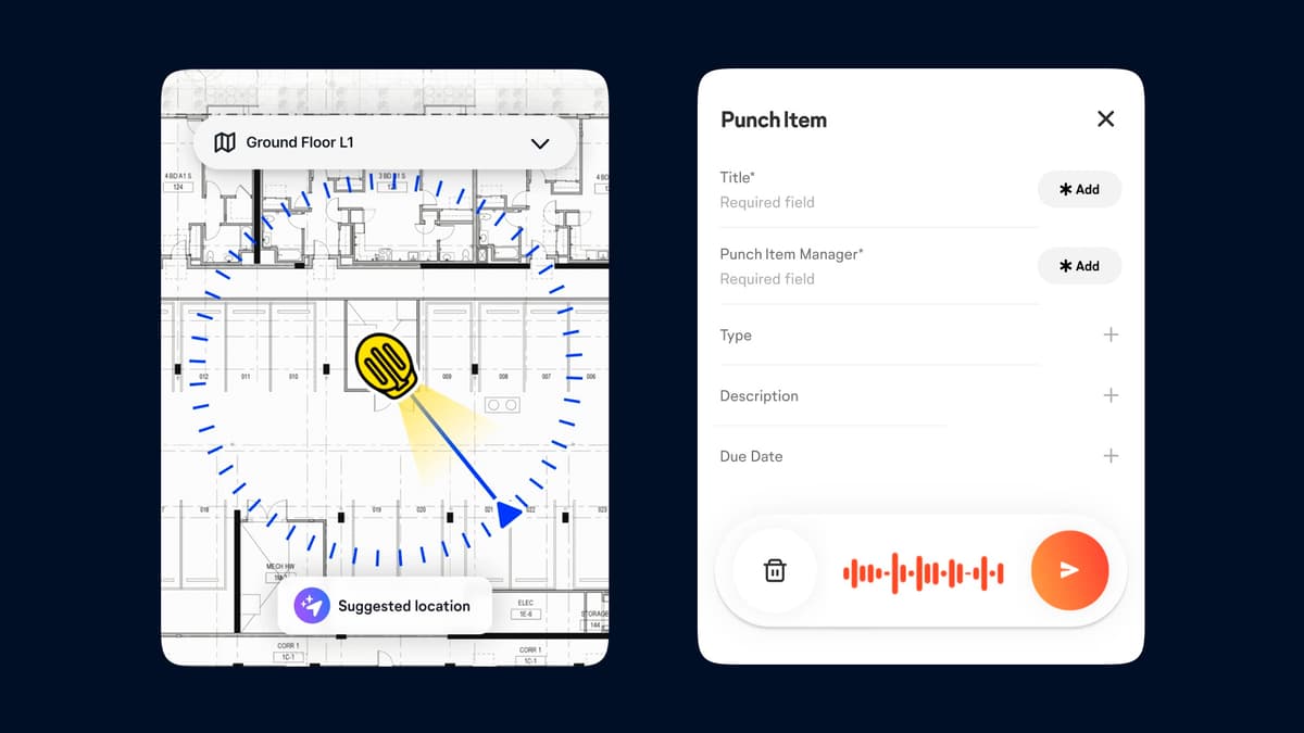
OpenSpace Field Launches for Construction Teams
OpenSpace has launched Field, an image‑based mobile solution that lets construction crews capture snagging items, observations and issues in real time. The platform leverages AI autolocation to tag the exact spot of a problem using a smartphone and prior 360°...

Grimshaw Moves to Inevidesk VDI Platform
Grimshaw has completed a firm‑wide migration of its UK and European design teams onto Inevidesk’s virtual desktop infrastructure, replacing a centralized rack of physical workstations with cloud‑based virtual desktops. After a pilot deployment for its visualisation team in 2024, the...
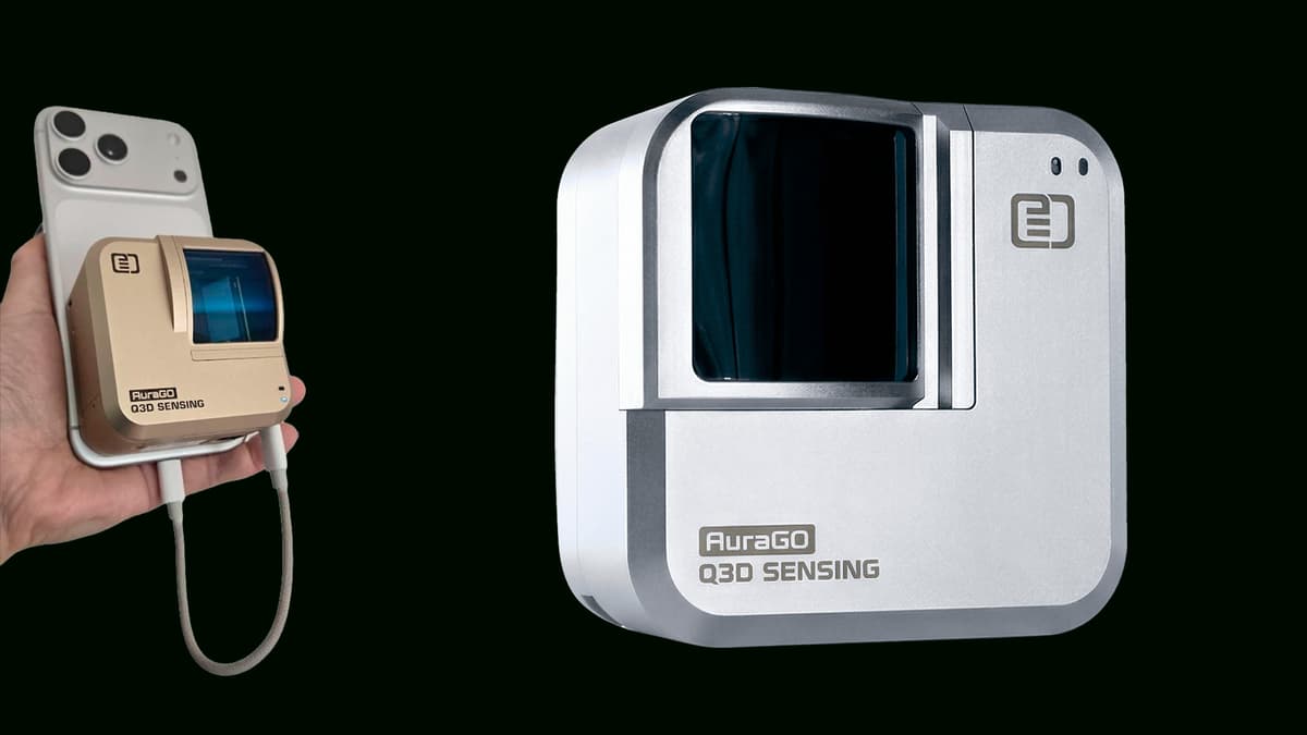
Q3D Sensing Unveils AuraGO
Q3D Sensing announced the AuraGO, a compact add‑on LiDAR scanner that attaches to smartphones and tablets. The device promises centimetre‑level accuracy and a working range of 0.5 m to 30 m, delivering roughly 100 times the coverage of built‑in phone LiDAR. AuraGO...

Hexagon Multivista Connects to Revizto
Hexagon Multivista has integrated its Analyze deviation‑detection service with Revizto’s BIM collaboration platform, enabling users to push clash and deviation data directly into Revizto’s issue log. The workflow lets project managers select individual or grouped deviations from reality‑capture scans and...
Autodesk’s $200m Bet on Spatial AI
Autodesk announced a $200 million strategic investment in World Labs, the spatial‑intelligence AI startup co‑founded by Stanford AI pioneer Fei‑Fei Li, as part of a $1 billion funding round that also includes Nvidia and AMD. The deal grants Autodesk an advisory role and...

Vectorworks Acquires iPad App Developer Morpholio
Vectorworks has acquired Morpholio, the creator of the iPad sketching trio Trace, Board and Journal, bringing the mobile tools under its desktop CAD and BIM umbrella. The three apps will continue as separate subscriptions on the App Store, while Vectorworks...

Cintoo Embraces Ricoh-Native 360 Data
Cintoo has launched a new 360 Edition that natively ingests Ricoh 360° video and merges it with 3D scans, BIM and CAD models in a single cloud‑based environment. The platform offers unlimited automatic camera‑path processing, manual alignment tools, and Gaussian‑splat visualisation for...
Esri and Pix4D Build Reality Capture Workflow
Esri and Pix4D have linked the PIX4Dcatch smartphone app with ArcGIS Online, creating a terrestrial‑mapping workflow that captures high‑precision 3D scans of trenches and subsurface infrastructure. The integration uses a real‑time kinematics (RTK) device to georeference scans at centimeter‑level accuracy,...