Sentinel-1's Decade of Essential Data over Shifting Ice Sheets
•January 7, 2026
0
Why It Matters
Reliable, continent-wide ice-flow data are essential for refining sea-level rise forecasts and assessing climate-change risks to coastal communities. The new baseline also enables rapid detection of future accelerations or slowdowns in ice discharge.
Key Takeaways
- •Sentinel-1 provides decade-long, 200‑250 m resolution ice‑velocity maps.
- •Antarctic Pine Island Glacier speed increased from 10.6 to 12.7 m/day.
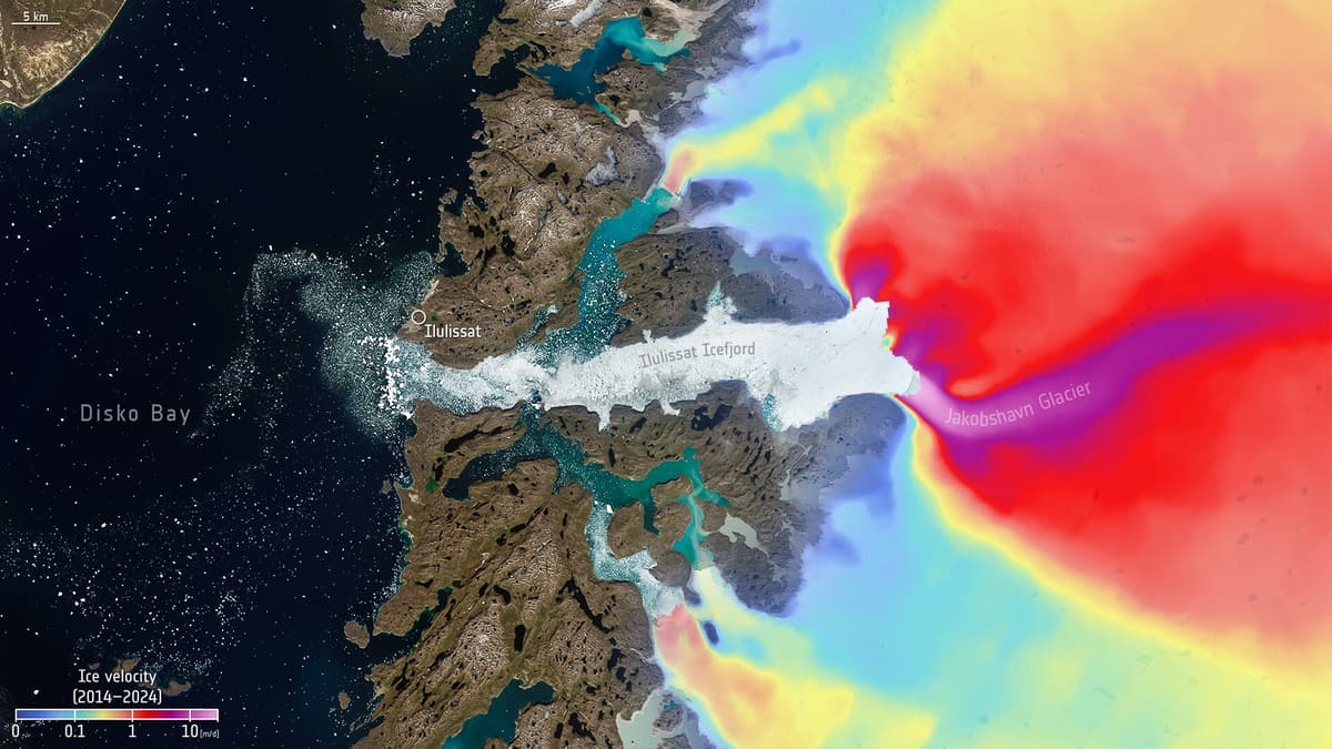
- •Jakobshavn Glacier reaches up to 50 m/day during peak flow.
- •Continuous SAR data improve sea‑level rise predictions and climate models.
- •Sentinel‑1D restores six‑day revisit, enhancing polar monitoring.
Pulse Analysis
Since its first launch in 2014, the Copernicus Sentinel‑1 constellation has become the workhorse of polar remote sensing. Its C‑band synthetic‑aperture radar penetrates clouds and darkness, delivering consistent, high‑resolution imagery every six to twelve days. By converting interferometric SAR measurements into velocity fields, scientists have built a decade‑long, continent‑wide archive that captures ice motion at 200‑250 m resolution. This continuity eliminates the patchwork of multi‑sensor mosaics that previously limited climate research, providing a single, reliable source for the cryosphere community.
The newly released velocity maps expose clear trends: Pine Island Glacier’s grounding‑line speed rose from roughly 10.6 m day⁻¹ to 12.7 m day⁻¹, while Greenland’s Jakobshavn outlet can surge past 50 m day⁻¹ during melt seasons. Such accelerations signal thinning ice shelves and grounding‑line retreat driven by warmer ocean waters. Incorporating these observations into sea‑level rise models reduces uncertainty, allowing policymakers to better gauge flood risk for low‑lying regions. Moreover, the dense time series supports attribution studies that separate natural variability from anthropogenic warming.
Looking ahead, Sentinel‑1’s legacy will be extended through the upcoming ROSE‑L mission, which will share a similar SAR payload and maintain the six‑day revisit cadence. The combined archives will ensure uninterrupted monitoring well beyond 2030, a critical asset as Arctic warming accelerates. For the broader climate‑policy arena, this persistent data stream underpins the Copernicus Climate Change Service’s cryosphere products, informing international reporting frameworks such as the UNFCCC. In short, Sentinel‑1 has turned polar ice dynamics from a series of snapshots into a measurable, actionable dataset.
Sentinel-1's decade of essential data over shifting ice sheets
0
Comments
Want to join the conversation?
Loading comments...