Three ESA-Built Satellites on Show in France
Companies Mentioned
Why It Matters
The launches will expand free, high‑resolution Earth data essential for climate research, disaster response and agricultural management, strengthening Europe’s strategic autonomy in space‑based observation.
Key Takeaways
- •FLEX will map global plant fluorescence to improve carbon cycle models
- •Sentinel‑3C extends Copernicus data for sea‑level, ice, and wildfire monitoring
- •MTG‑I2 will deliver 50× more weather data, enhancing European nowcasting
- •All three satellites cleared functional tests and head to French Guiana
- •ESA, EUMETSAT and European industry showcase collaborative Earth‑observation capability
Pulse Analysis
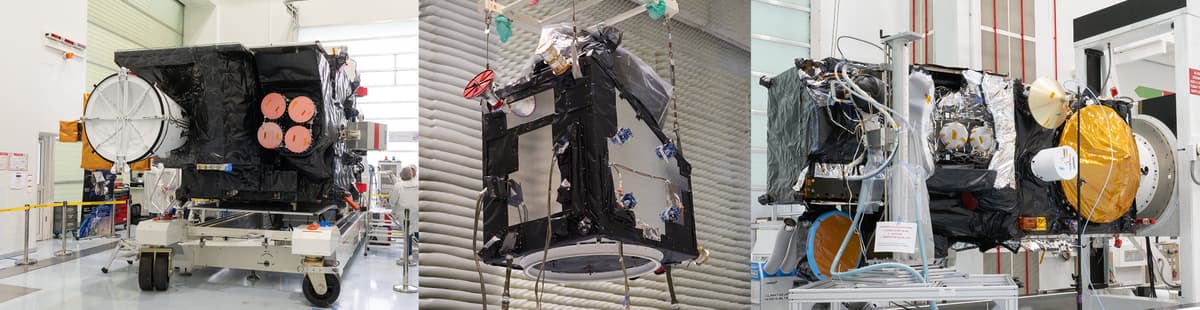
Europe’s Earth‑observation portfolio is reaching a pivotal moment as three flagship satellites—FLEX, the MTG‑Imager 2 and Sentinel‑3C—move from clean‑room validation to launch preparation. The successful completion of functional and environmental tests confirms that the hardware meets the rigorous standards required for long‑duration space missions. Hosted by Thales Alenia Space in Cannes, the media showcase highlighted the seamless handover to the Guiana Space Centre, where Ariane 6 and Vega‑C rockets will carry the payloads later this year. This coordinated rollout reflects a mature European supply chain, with more than 30 firms across France, Italy, Germany and Spain contributing components and expertise.
Each satellite addresses a distinct scientific niche while feeding into a broader data ecosystem. FLEX’s FLORIS spectrometer will detect faint vegetation fluorescence, offering unprecedented insight into photosynthetic efficiency and stress, a metric vital for refining global carbon‑cycle models. Sentinel‑3C, the workhorse of the Copernicus fleet, continues to deliver altimetry, ocean‑colour and land‑surface observations that underpin sea‑level rise assessments, ice‑sheet monitoring and wildfire detection. Meanwhile, MTG‑I2’s dual instruments—a Lightning Imager and a Flexible Combined Imager—promise 50‑times the data volume of previous Meteosat generations, dramatically improving nowcasting capabilities for severe weather across Europe and North Africa. The synergy between FLEX’s atmospheric context and Sentinel‑3C’s surface measurements will enable more accurate climate diagnostics.
The operationalization of these missions carries significant commercial and policy implications. Free, high‑quality Earth data strengthens Europe’s strategic autonomy, reducing reliance on non‑European providers and supporting the EU’s Green Deal objectives. Weather services, agribusinesses, insurance firms and disaster‑response agencies will gain richer, near‑real‑time datasets, fostering new analytics products and services. Moreover, the successful collaboration among ESA, EUMETSAT, the European Commission and industrial partners showcases a model for future multi‑mission programmes, reinforcing Europe’s position as a global leader in sustainable space technology. The upcoming launches therefore represent not just scientific milestones but also a catalyst for economic growth and climate resilience.
Three ESA-built satellites on show in France
Comments
Want to join the conversation?
Loading comments...