Unlocking Earth’s Secrets Through Hyperspectral Satellite Imaging
•January 16, 2026
0
Companies Mentioned
Why It Matters
By turning invisible chemical signatures into real‑time insights, hyperspectral data drives cost‑effective decision‑making across critical industries and accelerates climate‑action initiatives.
Key Takeaways
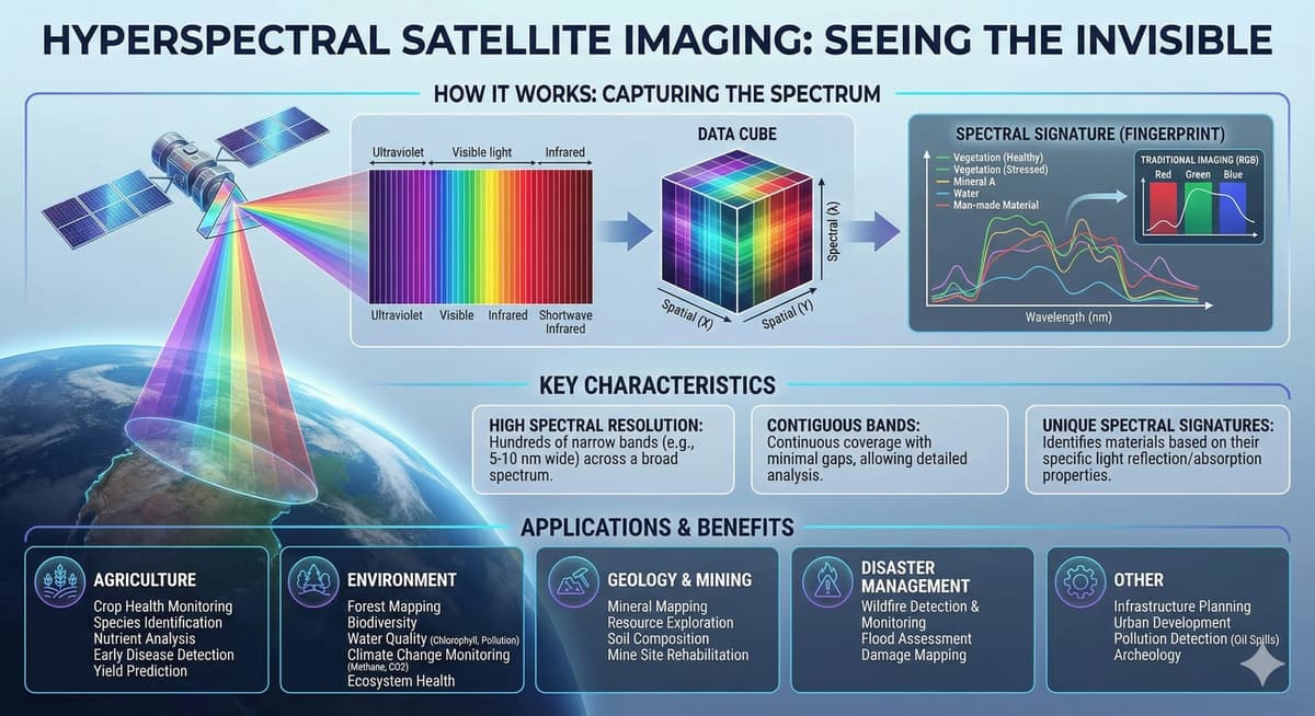
- •Hyperspectral sensors capture hundreds of narrow spectral bands
- •Enables early disease detection in crops
- •Detects methane leaks from space
- •Supports mineral mapping for critical resource discovery
- •Commercial constellations provide frequent global coverage
Pulse Analysis
The launch of compact hyperspectral payloads marks a paradigm shift in Earth observation. Unlike traditional multispectral satellites that record only a handful of broad bands, these new sensors generate continuous spectra for each pixel, exposing the unique chemical fingerprints of soils, vegetation, and man‑made materials. This granular view unlocks quantitative analysis—such as chlorophyll concentration or mineral absorption features—transforming raw imagery into precise, science‑grade datasets that can be integrated directly into enterprise analytics platforms.
In agriculture, the ability to spot subtle shifts in the red‑edge region or short‑wave infrared absorption enables farmers to intervene before stress becomes visible, slashing fertilizer and pesticide use while safeguarding yields. Environmental agencies leverage the same spectral precision to differentiate toxic algal species, map plastic debris, and pinpoint methane super‑emitters, providing regulators with verifiable, near‑real‑time evidence for enforcement. Meanwhile, mining companies accelerate exploration by mapping alteration minerals across vast terrains, reducing costly drilling campaigns and focusing investment on the most promising targets.
The commercial rollout is underpinned by advances in onboard AI and edge computing, which pre‑process terabytes of hyperspectral cubes and downlink only classified insights. This reduces bandwidth bottlenecks and lowers operational costs, making subscription‑based data services viable for a broader customer base. As launch costs continue to fall and sensor miniaturization improves spatial resolution, hyperspectral constellations are poised to become a staple of the new space economy, delivering the chemical intelligence needed for sustainable resource management and resilient supply chains.
Unlocking Earth’s Secrets Through Hyperspectral Satellite Imaging
0
Comments
Want to join the conversation?
Loading comments...