A Rainbow Patchwork Quilt Shows Agriculture From Space | Space Photo of the Day for June 4, 2026
Why It Matters
NISAR’s high‑resolution radar offers real‑time insight into crop conditions, helping farmers, insurers and policymakers mitigate risk and improve food‑security planning across a key global agricultural region.
Key Takeaways
- •NISAR launched July 28 2025, joint NASA‑ISRO radar mission
- •Image maps South Africa’s Maize Triangle using color‑coded vegetation data
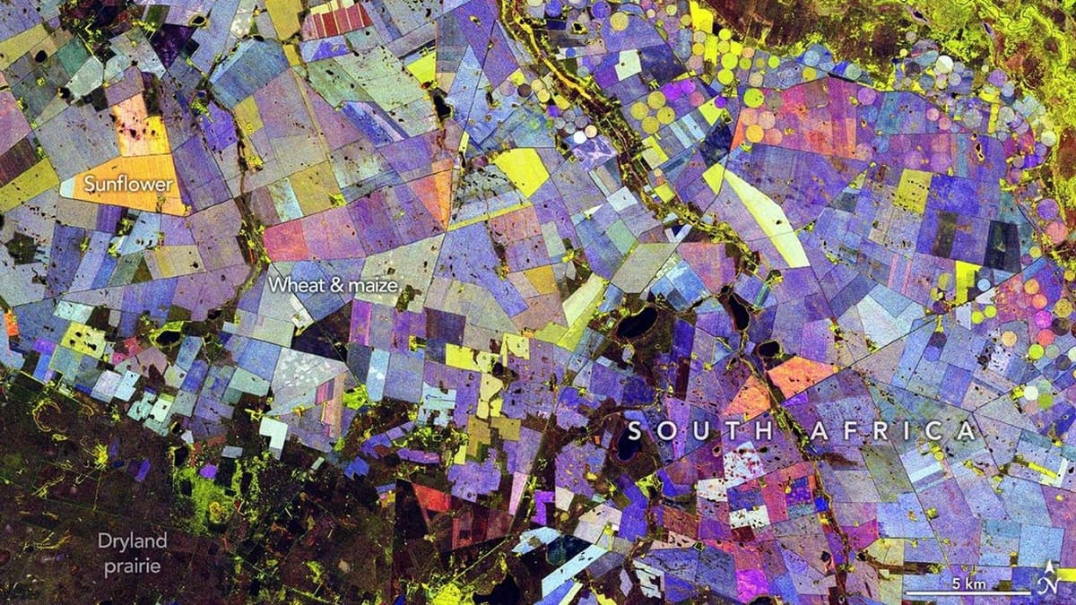
- •Green shows vegetation; red indicates bare soil; blue tracks change
- •Radar distinguishes crops like maize and sunflower from forest cover
- •Data aid farmers, insurers, and policymakers in crop monitoring
Pulse Analysis
The NASA‑ISRO Synthetic Aperture Radar (NISAR) mission represents a leap forward in Earth observation, pairing synthetic‑aperture radar with interferometric techniques to capture surface changes at a few‑meter resolution. Launched in mid‑2025, NISAR operates in L‑ and S‑band frequencies, enabling it to penetrate cloud cover and illuminate terrain regardless of lighting conditions. This all‑weather capability is crucial for consistent monitoring of dynamic environments, from flood‑prone river basins to rapidly shifting agricultural fields, and positions NISAR as a cornerstone of the next generation of climate‑science satellites.
In the latest composite, NISAR’s radar returns are translated into a rainbow‑like patchwork over South Africa’s Free State and North West provinces. Green hues denote healthy vegetation, red marks exposed soil, while shades of blue capture the rate of seasonal greening or browning. By distinguishing spectral signatures of crops such as maize and sunflower, the image offers a granular view of the Maize Triangle’s productivity. This level of detail supports precision agriculture initiatives, allowing growers to fine‑tune irrigation, fertilizer application, and harvest timing based on near‑real‑time biomass assessments.
The commercial and policy implications are significant. Agribusinesses can integrate NISAR data into yield‑forecast models, reducing uncertainty and optimizing supply‑chain decisions. Crop insurers gain a more objective basis for claim verification, potentially lowering premiums and accelerating payouts after droughts or floods. Moreover, governments can leverage the data to allocate resources, enforce land‑use regulations, and monitor the impacts of climate variability on food security. As more satellite constellations adopt similar radar technologies, the market for high‑frequency, cloud‑independent Earth data is poised for rapid expansion, driving innovation across the ag‑tech ecosystem.
A rainbow patchwork quilt shows agriculture from space | Space photo of the day for June 4, 2026
Comments
Want to join the conversation?
Loading comments...