How Satellites Caught The Rise Of The Next El Niño
Why It Matters
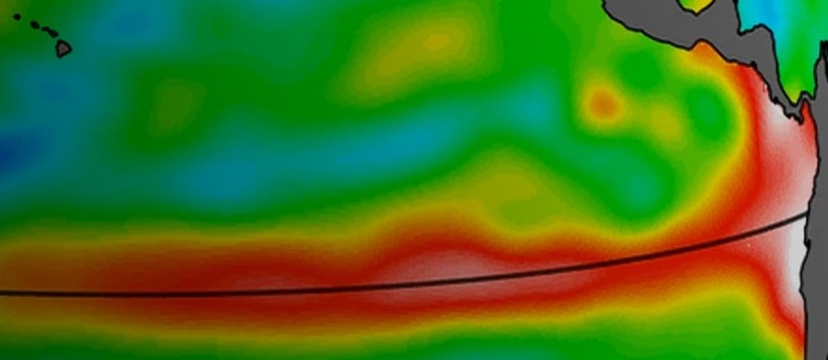
Identifying Kelvin waves months ahead sharpens El Niño forecasts, allowing governments and businesses to mitigate risks to agriculture, water resources and supply chains. The data underscores the strategic value of international satellite collaborations for climate resilience.
Key Takeaways
- •Sentinel-6 recorded a 5.9‑inch sea‑level rise off Peru.
- •Warm Kelvin wave moved eastward from western Pacific to South America.
- •Early Kelvin wave signals raise probability of an El Niño this year.
- •Multi‑agency Sentinel‑6 mission provides continuous ocean temperature data.
- •El Niño can shift global rainfall, affecting agriculture and economies.
Pulse Analysis
The Sentinel‑6 Michael Freilich satellite, part of the Copernicus Sentinel‑6/Jason‑CS program, blends advanced altimetry, microwave radiometry and laser ranging to deliver high‑resolution ocean observations. Managed jointly by ESA, EUMETSAT, NASA and NOAA, the platform offers a seamless data stream that bridges gaps left by earlier missions, reinforcing the global climate‑monitoring architecture. Its ability to measure sea‑surface height to a few centimeters and temperature anomalies in near‑real time makes it a cornerstone for scientific research and operational forecasting.
During the spring of 2026, Sentinel‑6 detected a pronounced Kelvin wave—a fast‑moving, eastward‑propagating warm water anomaly—originating near Micronesia and advancing toward the Peruvian coast. By mid‑May, sea‑level anomalies reached roughly 15 cm above the long‑term mean, a clear indicator of surface warming. Such thermal signatures are precursors to El Niño events, and their early identification allows climate models to adjust probabilities months before traditional atmospheric indicators emerge, improving the lead time for preparedness measures.
The broader impact of an imminent El Niño extends beyond meteorology. Shifts in the Pacific’s heat distribution can trigger heavier rains in the southern United States and droughts in parts of Southeast Asia, directly influencing crop yields, water management and commodity markets. Early satellite‑based warnings enable policymakers, insurers and supply‑chain managers to recalibrate risk assessments, allocate resources for flood defenses, and adjust planting schedules. Continued investment in multi‑agency satellite constellations thus not only advances scientific understanding but also underpins economic stability in a climate‑sensitive world.
How Satellites Caught The Rise Of The Next El Niño
Comments
Want to join the conversation?
Loading comments...