Mini Lake Meets Snowy Rim of Canada's Oldest Ice Mass — Earth From Space
Why It Matters
The image highlights the rapid changes afflicting Arctic glaciers, underscoring climate‑driven melt that reshapes sea levels, ocean currents, and regional land‑rebound dynamics. Monitoring such legacy ice bodies is critical for refining climate models and adaptation strategies.
Key Takeaways
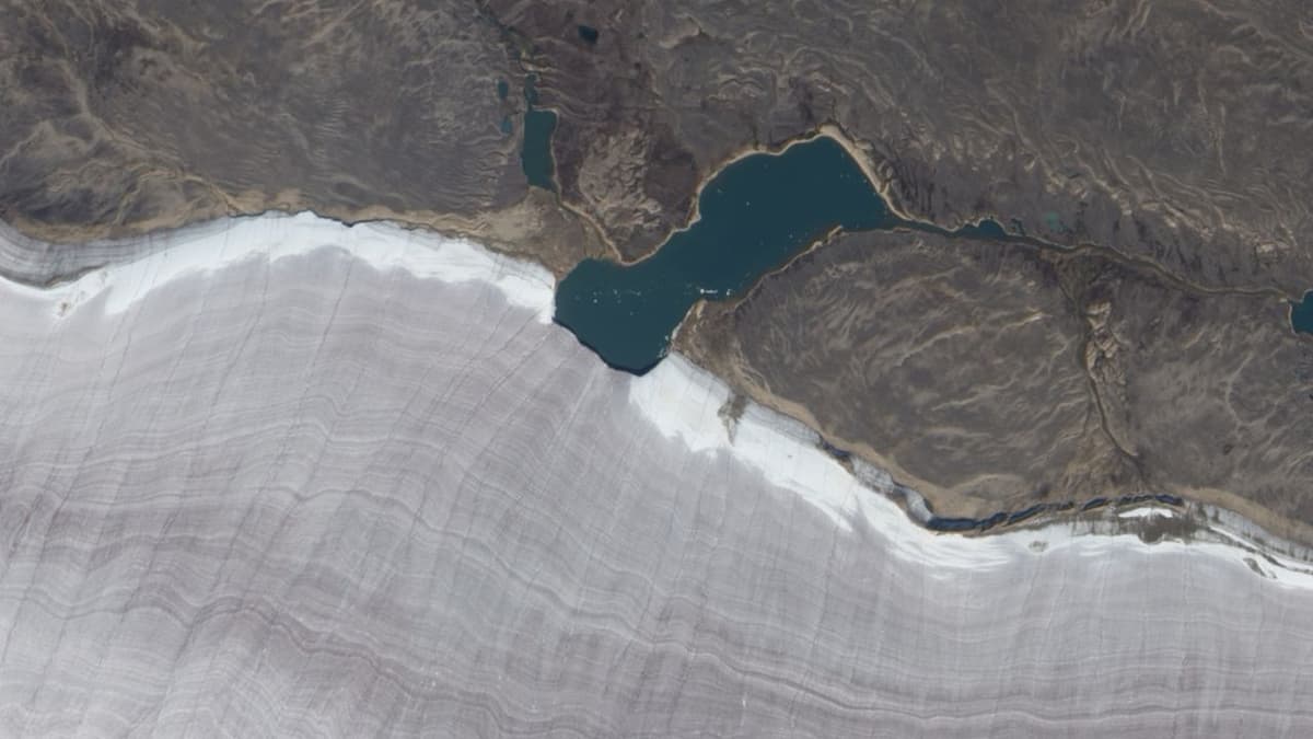
- •Gee Lake spans ~3.2 km across, cutting Barnes Ice Cap’s rim.
- •Barnes Ice Cap holds ice up to 20,000 years old, last Laurentide fragment.
- •Ice thickness reaches ~500 m; surface shows melt‑water striations.
- •Glacier retreats a few meters annually, may vanish within 300 years.
- •Meltwater alters ocean currents and triggers regional land‑rebound effects.
Pulse Analysis
Satellite remote sensing has become indispensable for tracking the health of Earth’s cryosphere. NASA’s EO‑1 platform, with its high‑resolution multispectral capabilities, revealed the stark contrast between the dark, dust‑laden ice of the Barnes Ice Cap and the surrounding snow‑free terrain. Such imagery not only provides a visual record but also supplies quantitative data on surface albedo, melt‑water pathways, and glacier geometry—key inputs for predictive climate models.
The Barnes Ice Cap is more than a picturesque Arctic feature; it is a living archive of the last ice age. Ice cores extracted from its depths contain layers that span the full 20,000‑year history of the Laurentide Ice Sheet, offering scientists a rare window into past atmospheric composition, temperature fluctuations, and volcanic events. As the sole surviving fragment of a once‑vast ice sheet that sculpted the Great Lakes basin, the cap serves as a benchmark for understanding long‑term glacial dynamics and the geological rebound occurring across North America.
Yet the cap’s future hangs in the balance as global temperatures climb. Current retreat rates of only a few meters per year may seem modest, but accelerated melt could unleash fresh water into the North Atlantic, perturbing thermohaline circulation and amplifying climate feedbacks. Moreover, the redistribution of mass from melting ice contributes to isostatic uplift, influencing sea‑level projections for coastal cities. Continuous monitoring of Gee Lake and the Barnes Ice Cap thus informs both scientific inquiry and policy decisions aimed at mitigating the cascading impacts of Arctic ice loss.
Mini lake meets snowy rim of Canada's oldest ice mass — Earth from space
Comments
Want to join the conversation?
Loading comments...