The Collisional Origin of Umm Chaimin Depression in Western Iraq: A Synthesis of Geological and Geomorphological Evidence
Why It Matters
Validating Umm Chaimin as an impact site reshapes regional geological models and creates opportunities for scientific tourism and resource exploration, while providing a natural laboratory for post‑impact processes in arid settings.
Key Takeaways
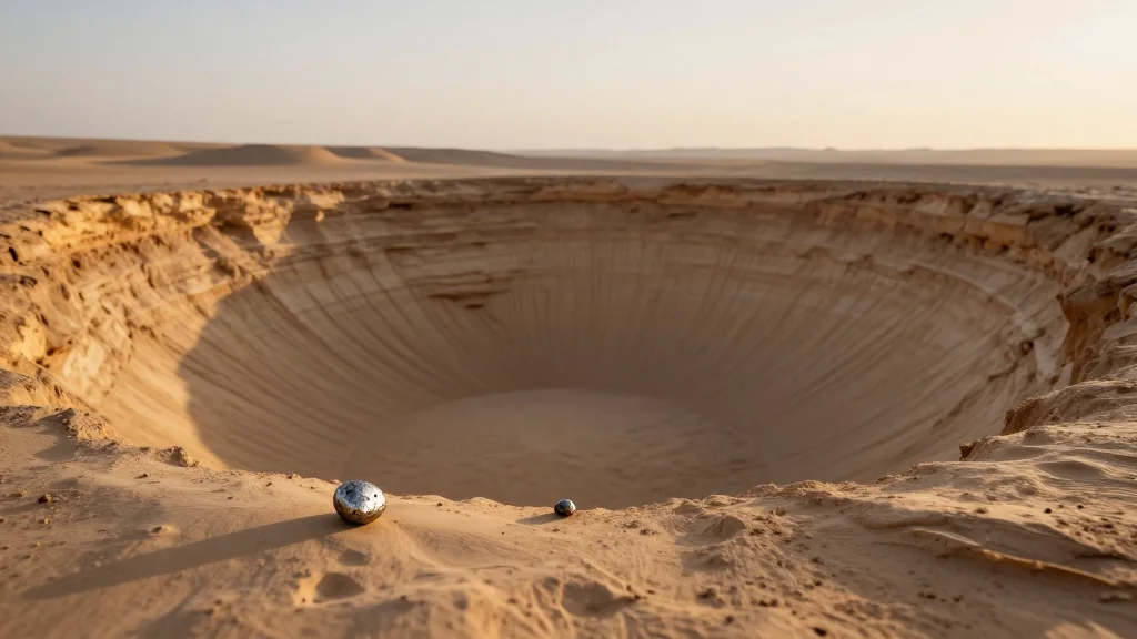
- •Impact origin confirmed by 30 m depth and semi‑circular shape
- •Quartz‑prehnite minerals indicate low‑temperature shock metamorphism
- •Radial drainage patterns reflect impact‑driven topography
- •Largest confirmed impact crater in the Middle East
- •Study urges conservation and further multidisciplinary research
Pulse Analysis
The discovery of a well‑preserved impact structure in western Iraq adds a rare data point to the global inventory of terrestrial craters. While most known sites cluster in stable continental interiors, Umm Chaimin sits within the tectonically active Arabian Plate, offering a unique perspective on how moderate‑strength impacts interact with Eocene and Quaternary sedimentary sequences. For geoscientists, the crater provides a natural experiment to test models of shock metamorphism, ejecta distribution, and post‑impact erosion under arid climate conditions. These data also help calibrate remote‑sensing algorithms for crater detection worldwide.
The field campaign combined high‑resolution topographic mapping with petrographic microscopy, revealing a 30‑meter‑deep, semi‑circular basin bounded by quartz‑rich breccias and prehnite veins. These mineral assemblages are hallmarks of low‑grade shock, confirming an impact rather than volcanic or karst origins. Drainage analysis shows concentric and radial stream networks that have re‑worked the crater floor since formation, illustrating how impact‑generated topography can dominate hydrological pathways in desert settings. The findings also suggest that similar buried structures may be identified using integrated geophysical surveys.
Beyond academic interest, Umm Chaimin holds commercial promise. Impact structures often concentrate mineralized zones, and the surrounding Eocene‑Quaternary strata could host hydrocarbon reservoirs that benefit from the crater’s structural trap. Moreover, the site’s rarity and size make it a candidate for geotourism, potentially generating revenue for local communities while raising awareness of Iraq’s geological heritage. Strategic partnerships with universities and energy firms can accelerate field studies and responsible resource exploitation. Protecting the depression from uncontrolled excavation and promoting interdisciplinary research will ensure that the crater serves both scientific discovery and sustainable economic development.
The Collisional Origin of Umm Chaimin Depression in Western Iraq: A Synthesis of Geological and Geomorphological Evidence
Comments
Want to join the conversation?
Loading comments...